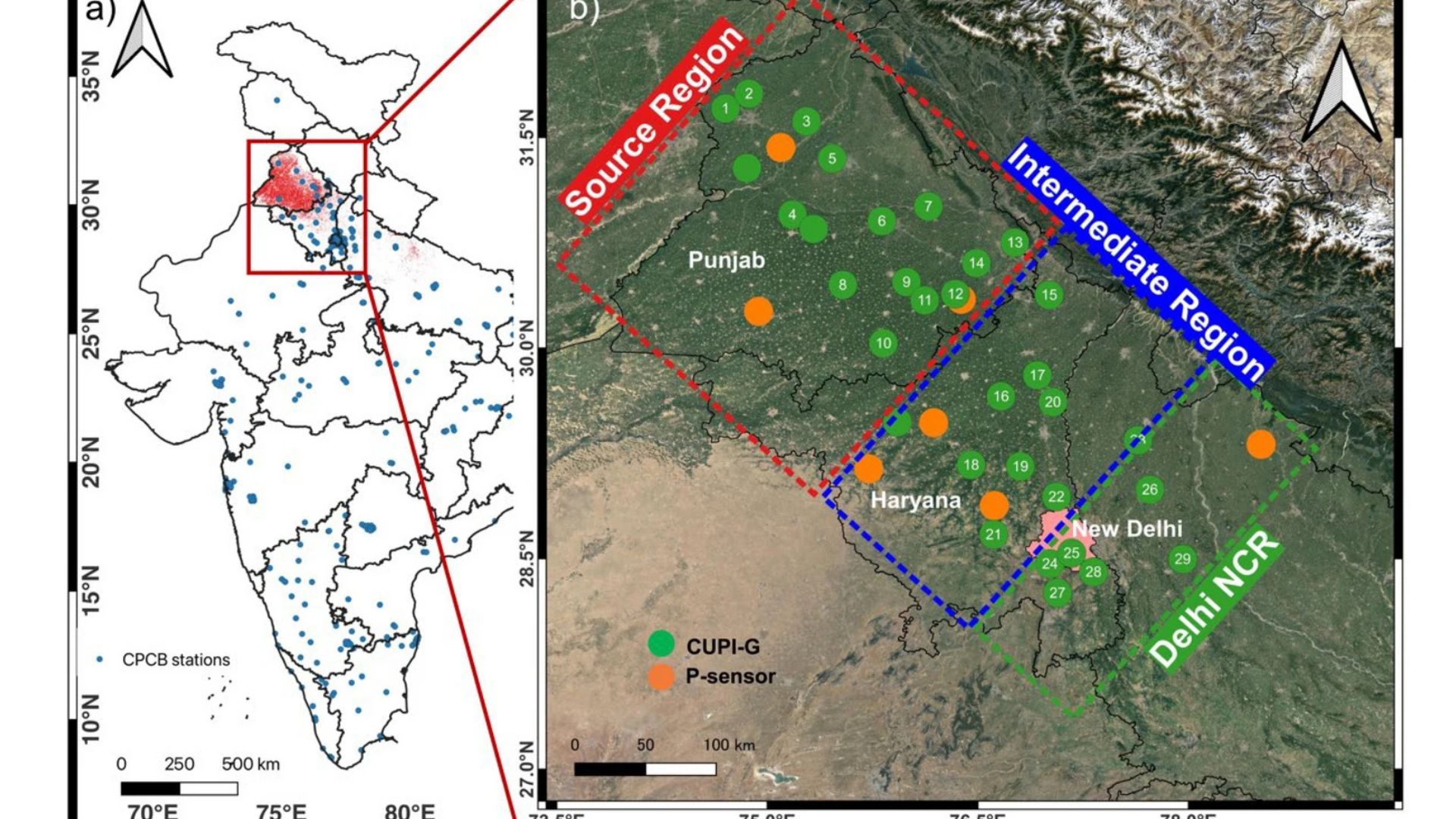
Scientists have successfully tracked immense plumes of toxic air travelling from agricultural fields in northwest India directly into the densely populated capital, Delhi, using a newly deployed network of ground sensors. During the post-monsoon season of 2022, a joint team of researchers from India and Japan installed a high-density grid of continuous air quality monitors across the states of Punjab, Haryana, and the Delhi National Capital Region. Their goal was to understand exactly how the annual burning of crop residues creates severe
regional pollution crises that impact tens of millions of people. The team included researchers from the Research Institute for Humanity and Nature, Japan; Nagoya University, Japan; the Postgraduate Institute of Medical Education and Research (PGIMER), Panjab University; Jawaharlal Nehru University; and others.
Every year between September and November, farmers in Punjab and Haryana burn leftover paddy stubble to quickly and cheaply clear their fields for the next planting season. This process releases huge amounts of fine particulate matter measuring less than 2.5 micrometres in diameter, known as PM2.5. These microscopic particles are incredibly dangerous because they are small enough to bypass the body's natural defences, travelling deep into the lungs and even entering the bloodstream.
By placing sensors directly in the wind's path, the researchers tracked two massive plumes of PM2.5 originating in rural fields in Punjab, sweeping across the state of Haryana and eventually choking Delhi, with a delay of 1 to 3 days. Interestingly, the scientists discovered that while the farmers usually set the fires at midday when the weather is dry, the pollution at ground level actually peaks during the midnight and early morning hours. This delayed spike is driven by the physics of the planetary boundary layer, the lowest part of Earth's atmosphere. As air temperatures drop at night, the boundary layer becomes shallow, acting like a lid that traps smoke close to the ground, where people breathe.
Until now, authorities have largely relied on satellite imagery and official air quality monitoring stations that are strictly concentrated within large urban centres. However, satellites are frequently blinded by the very clouds and thick haze that accompany these severe pollution events, leading to critical gaps in tracking the smoke. Furthermore, computer models used to predict pollution often suffer from uncertainties regarding emission amounts and chemical changes in the air. By installing 32 robust sensors directly in rural farming villages, areas traditionally ignored by pollution monitors, the scientists were able to measure the exact origins and movement of the smoke in real-time, completely bypassing the issue of cloud cover. Crucially, the study revealed that these rural communities are suffering from extreme, sustained pollution levels, with hourly concentrations frequentlyexceeding 1000 micrograms per cubic metre, a hazardous reality previously invisible to city-centric networks.
While the new sensor network successfully mapped the physical movement of PM2.5 plumes, the researchers noted that the current findings do not fully separate fresh smoke from secondary particulates, which form when various gases react in the atmosphere over several days of transport. Future studies will need to utilise complex atmospheric chemistry-transport models and analyse other gases measured during the campaign, such as ozone, nitrogen oxides, and carbon monoxide, to get a complete chemical picture of the haze.
Nevertheless, by showing exactly how, when, and where agricultural smoke travels to densely populated megacities, meteorologists and authorities can now develop highly accurate early warning systems for hazardous smog events, allowing schools to close and vulnerable citizens to protect themselves in advance. Furthermore, by uncovering the hidden extremes of rural air pollution, this research highlights an urgent need for environmental policies that protect the health of farming communities at the source of the fires, rather than focusing solely on urban air quality.



