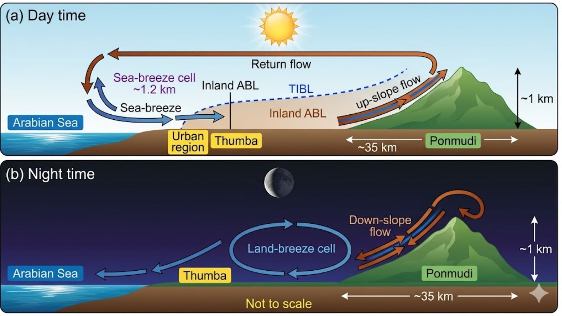
Scientists from the Vikram Sarabhai Space Centre (VSSC-ISRO) and Cochin University of Science and Technology have uncovered how daily coastal breezes and mountain winds combine to lift harmful black carbon pollution from coastal towns into pristine mountain environments. Using continuous data collected between 2015 and 2019 from two closely situated locations in Southern India, the researchers tracked the movement of black carbon from the coast to the hills. Their findings reveal that while large-scale seasonal weather patterns dictate the overall amount of pollution in the region, the distinct, daily rhythm of local winds controls how this pollution scales the mountainous terrain.
Black carbon, commonly known as soot, is a fine, dark aerosol produced by the incomplete burning of fossil fuels and biomass. It is a potent climate warmer because it absorbs sunlight strongly, heats the surrounding air, and can even alter cloud formation and weather patterns. The researchers continuously collected the tiny black carbon particles at two locations in Thiruvananthapuram in Kerala: Thumba, a coastal semi-urban area, and Ponmudi, a rural hill station in the Western Ghats located about 35 kilometres away and nearly a kilometre higher in altitude. They used instruments called aethalometers, which continuously draw in ambient air and pass it through a filter, to track the particles. By shining a light through the filter and measuring how much light it blocks, the scientists could calculate the mass concentration of black carbon deposited over a period. They also employed a computer simulation, the WRF-Chem model, to recreate atmospheric chemistry and wind patterns, allowing them to visualise the complex pathways the aerosols followed.
The continuous monitoring revealed stark differences in the daily life cycle of the pollution. At the coastal site of Thumba, black carbon levels showed sharp spikes in the morning and night. This is caused by local traffic emissions getting trapped near the ground by a shallow atmospheric layer before the sun’s heat breaks it up. However, at Ponmudi, high up in the mountains, pollution peaked in the afternoon. The researchers deduced that a handover process was occurring. During the day, the sea breeze pushes urban coastal pollution inland towards the hills. Simultaneously, the sun heats the mountain slopes, creating strong upward thermal currents known as valley breezes. These converging wind systems capture coastal soot and loft it high into the atmosphere, directly delivering it to the mountain peaks.
By placing continuous monitors at two geographically distinct but nearby sites over four years, this work provided a three-dimensional view of how pollution moves over the complex terrain. However, the researchers noted certain limitations in their computer models. The simulation struggled to perfectly replicate the sharp morning pollution spikes observed at the coast and slightly underestimated nighttime concentrations. Accurately simulating the tiny, complex air turbulence at the boundary where the ocean meets land is notoriously difficult and would require incredibly high-resolution modelling tools in the future.
Since black carbon significantly warms the atmosphere and disrupts regional weather patterns, understanding how local topography and winds distribute these particles is crucial for predicting the impacts of climate change. This knowledge empowers policymakers to develop highly targeted, regional air quality management strategies, helping to protect both the health of local populations and the fragile ecosystems of high-altitude environments.



