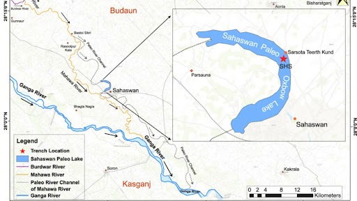
In the heart of the Central Ganga Basin, known as the "Food Bowl of India," a new study has shown how ancient earthquakes and shifting monsoon rains dramatically redrew the landscape and dictated the fate of early human societies over the last 4,500 years. By excavating into a dried-up lakebed, researchers extracted layers of mud and sand dating back centuries. These sediment layers act as a natural time capsule, revealing a detailed history of extreme droughts, river migrations, and cultural upheaval.
The study by researchers from Indian Institute of Technology (IIT) Kharagpur, Inter University Accelerator Centre, Indian Institute of Technology (IIT) Roorkee, and Indian Institute of Science Education and Research (IISER) Kolkata reveals that a combination of deep underground tectonic activity and severe fluctuations in the Indian Summer Monsoon caused mighty rivers to suddenly change their courses, leaving behind curved lakes and forcing ancient populations to abandon their homes in search of water.
Lakes act as natural sediment traps. During periods of heavy monsoon rains, fast-moving floodwaters carry coarse sand into the lake, while droughts leave behind only very fine clay and silt. To examine the region’s history, researchers excavated a 3.3-meter-deep trench into a completely dried-up oxbow lake near the town of Sahaswan in Uttar Pradesh. They then physically sliced the sediment core into 165 samples at 2-centimetre intervals. By using a laser particle size analyser, the scientists could measure the exact grain sizes in each layer to estimate past rainfall intensity. Furthermore, they used X-ray fluorescence to determine the soil's chemical composition.
Elements like calcium and strontium indicated warm, wet periods with thriving aquatic life, while high levels of rubidium pointed to colder, drier times when rocks were physically broken down by harsh climates. They also examined the carbon isotopes of the organic matter, which revealed whether the surrounding plants were the type that flourished in wet environments or those that survived in arid conditions. To pinpoint exactly when these climatic shifts occurred, the team used accelerator mass spectrometry to radiocarbon-date fossilised shells and organic matter, creating a highly accurate timeline stretching back nearly 4,500 years.
The researchers discovered that the Sahaswan oxbow lake was not formed solely by climate, but was heavily influenced by tectonic activity. Intermittent movements along deep underground fault lines, specifically the Hathras-Sirauli Fault, a subsidiary of the Great Boundary Fault, altered the slope of the land. This caused the ancestral Mahawa River to suddenly abandon its channel, a process called river avulsion, and shift southwest. This left behind a cut-off depression that filled with water, becoming the Sahaswan lake.
By analysing lake sediments, the scientists reconstructed a detailed timeline of the Indian Summer Monsoon (ISM) spanning 4,467 to 525 years ago. They also identified distinct periods of severe drought and abundant rainfall. The study found that the lake began to shrink around 800 years ago due to decreasing rainfall. By the beginning of the Little Ice Age, around 650 years ago, the monsoon had weakened so significantly that the Sahastral Lake completely dried up.
The researchers linked these geological and climatic changes directly to the rise and fall of ancient civilisations in the region. The severe droughts at 4,200 and 3,200 years ago caused massive crop failures and reduced agricultural productivity. This likely forced ancient societies, including populations of the Indus Valley Civilisation, to abandon their settlements and migrate eastward in search of more stable water sources.
Prolonged wet phases, such as the Roman Warm Period between 3,000 and 1,400 years ago, enabled surplus agriculture that supported the economic growth of the “Golden Age of India" under the Maurya and early Gupta empires. Conversely, the subsequent dry phase, known as the Dark Ages Cold Period between 1,400 and 1,000 years ago, undermined the agrarian revenue of the Gupta Empire, contributing to its economic deterioration and gradual political decline.
The new research weaves together climate data and the geological mechanics of river evolution to understand the region's history and how it has changed over time. It shows that the Central Ganga Basin is a highly dynamic tectono-climatic landscape, where sudden fault movements and fluctuating monsoon rains directly determine water availability, agricultural success, and the survival of ancient human populations. As global climate change threatens to disrupt monsoon patterns once again, the survival strategies of ancient societies offer a lesson in human resilience, helping modern India prepare its drinking water and agricultural infrastructure for the environmental challenges of tomorrow.



